
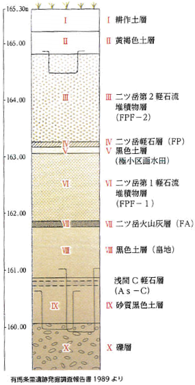
Soil strata of the Arima Jōri site
Atop black soil accumulated from the Yayoi into the Kofun periods, there are deposits of 10 cm of volcanic ash (FA) and a mud flow layer 1.5 m thick from an eruption at the start of the six century, covering the cultivated layer. Above this another 10 cm of black soil was deposited, and even as the area was thus revitalized as rice paddy, 10 cm of pumice (FP) plus another 1.5 m of mud flow were again deposited by a mid-sixth century eruption. Adapted from Hakkutsu sareta Nihon rettō 2016 [Excavations in the Japanese Archipelago, 2016] (Bunkachō [Agency for Cultural Affairs], ed., Kyodo News, 2016). Originally from Arima Jōri iseki hakkutsu chōsa hōkokusho [Arima Jōri Site Excavation Report], Gunma Prefectural Board of Education, 1989.
Furrows of cultivated fields
These were detected directly beneath the volcanic ash (FA) and mud flow layer from the eruption at the start of the sixth century. Blackened depressions are pit structures from the Yayoi to the start of the Kofun periods. By the start of the sixth century, tableland which had been a residential precinct had been developed as a vast area of farmland.
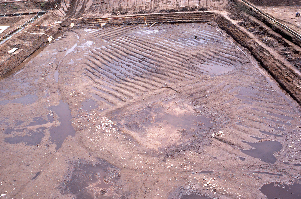
Micro paddy sector rice field
These features were detected immediately below the pumice (FP) and mud flow layers from the mid-sixth century eruption. On top of the thickly deposited early sixth-century ash (FA) and mud flow layers, rice paddy with sectors roughly 1 m wide by 1.5 m long, to which water could be circulated efficiently over a sloped area, had been developed.
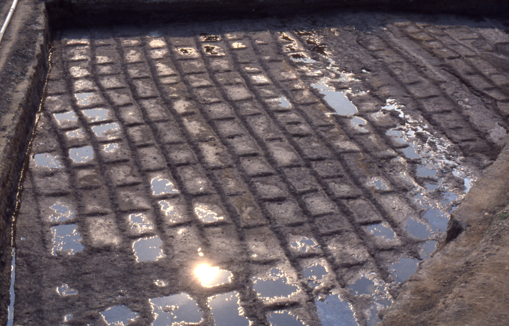
Pit structures
The pit structures were built atop the tableland surface (on the right side of the photo) after the pumice (FP) and mud flow layers of the mid-sixth century were deposited. To the left is the rice paddy level detected under the pumice and mud flow layers.
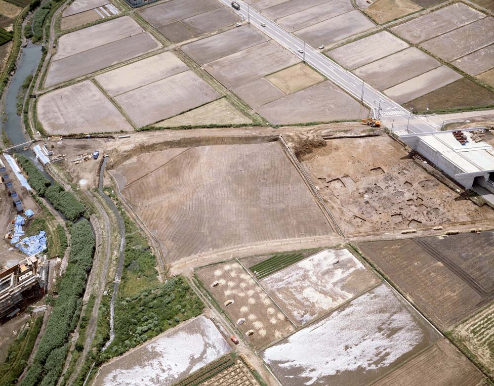
Arima Jōri Site, Shibukawa City, Gunma Prefecture
Kofun (sixth century)
The Arima Jōri site is located at the foot of the eastern slope of Mt. Haruna, atop a slight elevation at the tip of an alluvial fan. Mt. Haruna erupted violently twice in the sixth century, and from the changes in features above and below the layers of ejected volcanic matter from both eruptions, it is possible to see how people of the Kofun period overcame the disaster and achieved recovery each time.
From the Yayoi into the Kofun periods, a settlement was maintained at this site. At the start of the Kofun period arable lands were expanded and farmland opened up atop a tableland, but this farmland was buried by ash and mud flow from the initial eruption of Mt. Haruna at the start of the sixth century. As a result of excavation, rice paddy was discovered above the mud flow, buried under pumice from the mid-sixth century. This paddy was comprised of micro paddy sectors, in order expand the paddy over an area of slope.
The people of the Arima Jōri site thus utilized technology in practice in every region of the day, newly digging water channels into wasteland covered by the volcanic mud flow, skillfully circulating water over an area of slope to revitalize the farmland as rice paddy. The amount of time required for this reconstruction is unclear, but it had been completed during the 20 to 30-year interval before the next eruption.
Subsequently this area was visited again by a volcanic eruption in the mid-sixth century, and the paddy was completely buried with pumice and mud flow. But shortly thereafter, in the latter half of the sixth century pit structures were built on top of the mud flow layer, and occupation continued to the eleventh century. This time the residents probably revitalized low-lying arable lands in the surrounding area as rice paddy. The local address of the site is even now called Arima Tanbo (“Arima paddy”) and is an area of paddy. Beneath the modern fields survives the history of sturdy people who achieved the revitalization of those agricultural lands. (Kojima Atsuko)