Motodaka:
The oldest keyhole tomb in the San’in region. A water
management facility is discovered on the plain immediately below.
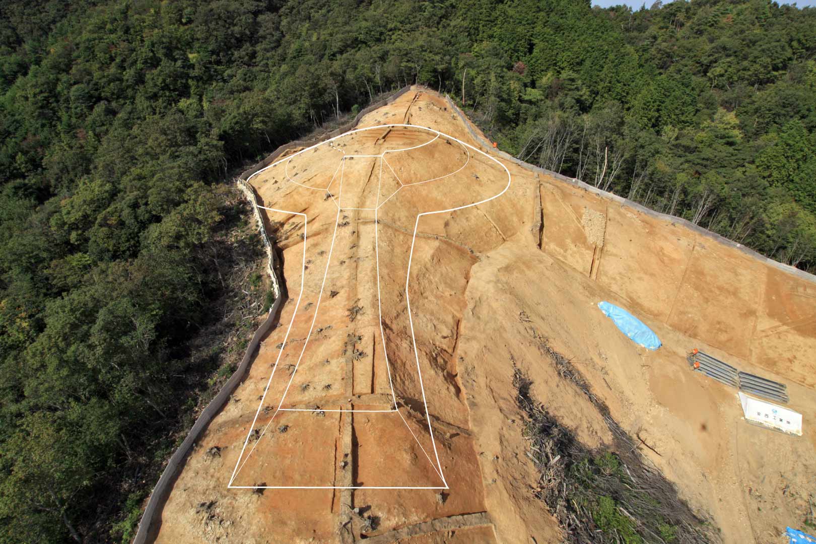
Motodaka No. 14 tomb (from the east) In contrast to the southern side (to the left in the photograph), where the shape of the mound is unclear because the slope has collapsed, on the northern side the junction between the round and front portions of the mound is clearly visible, and the shape of the front portion is also well preserved. Neither cobbles for paving the surface nor haniwa were recovered. This is a common characteristic often seen in keyhole tombs from the start of the Kofun period in the Sea of Japan coastal region. |
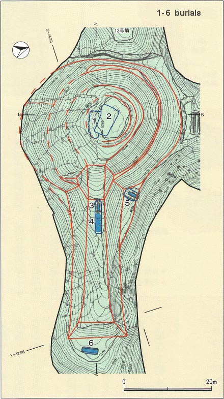
Scale drawing of Motodaka No. 14 The mound was shaped by cutting back the ridge and adding fill in limited fashion. The overall length is 63 m, and the ratio of the front and round portions is 1:1. The front portion is long and narrow, and flares slightly at the end. This type of front portion is characteristic of keyhole tombs of the initial stage within the Early Kofun period. The front portion is built as a single tier, and the back as two. A total of 6 burial facilities were found, 2 in the round portion (Burials 1 and 2), 2 in the front portion (Burials 3 and 4), and 1 each on the northern side at the junction between the round and front portions (Burial 5) and at the end of the front portion (Burial 6). Adapted from Hakkutsu
sareta Nihon rettō 2012
[Excavations in the Japanese Archipelago, 2012] (Bunkachō
[Agency for Cultural Affairs], ed., Asahi Shimbun Publications,
2012).
|
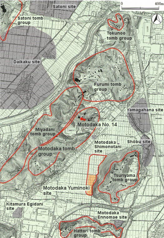
Map of relations among sites in the area Adapted from Hakkutsu
sareta Nihon rettō 2012
[Excavations in the Japanese Archipelago, 2012] (Bunkachō
[Agency for Cultural Affairs], ed., Asahi Shimbun Publications,
2012).
|
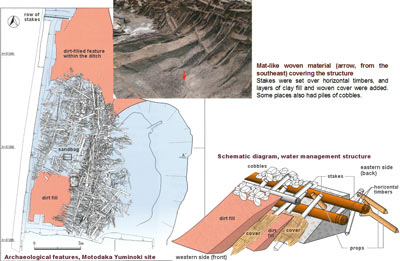
Plan of the Motodaka Yuminoki site (marked in orange on the accompanying map) Adapted from Hakkutsu
sareta Nihon rettō 2012
[Excavations in the Japanese Archipelago, 2012] (Bunkachō
[Agency for Cultural Affairs], ed., Asahi Shimbun Publications,
2012).
|
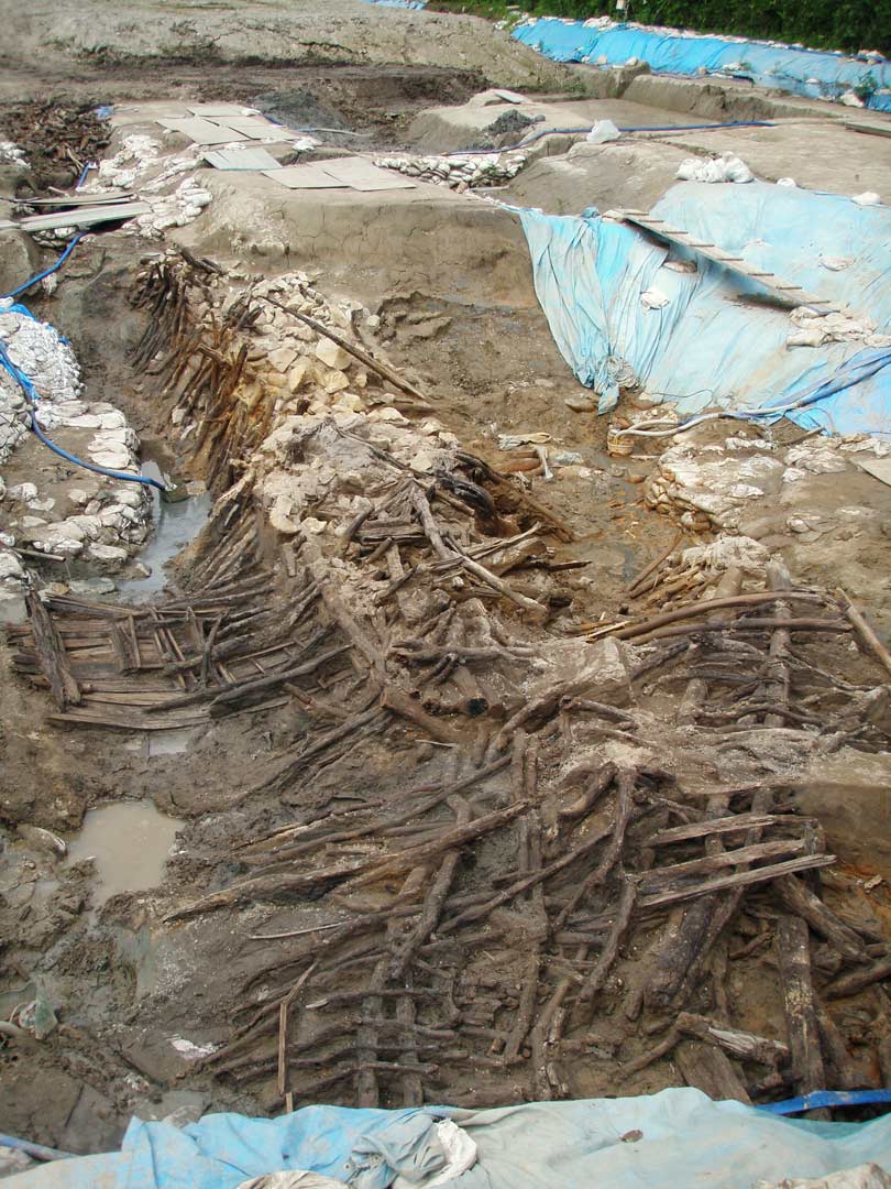
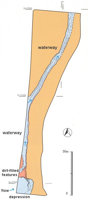
Structural features and waterway of the Motodaka Yuminoki site (from the south) Multiple structural features were built within the depression found on the southern side of the excavation precinct. These were repaired when they broke or became buried under sand, so that many features overlay one another. Approximately 3,000 pieces of lumber were utilized. |
Adapted
from Hakkutsu sareta
Nihon rettō 2012
[Excavations in the Japanese Archipelago, 2012] (Bunkachō
[Agency for Cultural Affairs], ed., Asahi Shimbun Publications,
2012).
|
Motodaka Tomb Group and Motodaka Yuminoki Site, Tottori City, Tottori Prefecture
Oldest keyhole tomb in the San’in region
Atop the Motodaka hill, on the western side of the Sendai river flowing through the Tottori plain, lies the Motodaka tomb group, built with a total of 20 tombs. As a result of excavation conducted in 2009, it became clear that Motodaka No. 14, thought to have been a round mound of the largest scale, is the oldest keyhole tomb in the San’in region.
Because the shape of the front portion is indistinct, Motodaka No. 14 had been assumed to be a round mound of about 20 m diameter, but after a topographic survey and excavation it was seen to be a keyhole tomb 63 m in overall length. From the shape of the mound a high possibility emerged of it being a keyhole built in the fourth century, and consideration was made to preserve it intact. Accordingly the burial facilities in the center of the round portion of the mound (marked 1 and 2 in the figure) were not excavated, but from the characteristics of a small round-bottomed jar placed on top of the coffin in a burial discovered at the junction of the round and front portions (marked 5 in the figure), it became clear that it was built in the first half of the fourth century.
Until now the appearance of keyhole tombs in the San’in region was regarded as an event of the latter half of the fourth century. The discovery of Motodaka No. 14, which goes back a good quarter century before this traditional view, is of great significance for reconsidering the emergence and development of keyhole tombs in the San’in region.
An Early Kofun period water management facility and regional development
At the Motodaka Yuminoki site on the plain spreading directly in front of the Motodaka tomb group, a waterway running north-south through the excavation area, and a pond-shaped depression accompanied by a structural feature built with large amounts of lumber were discovered. Pottery from the first half of the fourth century was recovered, and the structure is regarded as having been functioning around the time the Motodaka No. 14 tomb was built.
The waterway is a large-scale example with a width of 5 m, and the structure placed within the depression is thought to have been a water management facility which drew water from the southwestern side of the site into the waterway. At the Motodaka Shimonotani site, by the foot of the Motodaka tomb group, remains of rice paddies maintained in the first half of the fourth century have been found. Water drawn into the waterway was perhaps used for working rice paddies.
Also, piled-up sandbags and woven material as covering for fill were recovered from within the structure. Piling sandbags is a civil engineering technique utilized in the Kofun period for making embankments or building tomb mounds. In order to make a sturdy, large-scale water management facility at the Motodaka Yuminoki site, cutting-edge engineering technology of the day was put to use. Also, repairs to this facility were carried out repeatedly when it eroded or broke down. It can be seen how vital this facility was to the people utilizing the plain at Motodaka at the time.
Regarding the construction of this large-scale water management facility which used the latest in civil engineering technology, the relationship with the group that built the first keyhole tomb in the San’in region comes to mind. The results of investigations at the Motodaka No. 14 tomb and the Motodaka Yuminoki site are important for considering the conditions of regional society in the Early Kofun period. (Hamada Tatsuhiko)
(principal artifacts, Motodaka Tomb Group and Motodaka Yuminoki Site,)
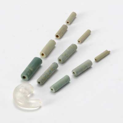
Comma-shaped and cylindrical beads Middle portion of the Early Kofun period (fourth century, first half). Length: (comma-shaped bead) 2.75 cm, (cylindrical beads) 1.4 – 2.45 cm. These were placed as grave goods in Burial 3 of the Motodaka No. 14 tomb. The comma-shaped bead is made of quartz crystal, and the cylindrical beads are green tuff. | 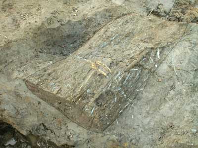
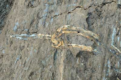
Sandbag Middle portion of the Early Kofun period (fourth century, first half). Length: 110.0 cm; width: 60.0 cm. Dirt was wrapped up with a mat woven of plant material, which appears to be the stalk of a grass of the family Poaceae, and the central portion bound with rope. After removal from the site, this item was preserved by freeze drying. This is the oldest example of a sandbag for which the material itself has survived in a good state of preservation. |
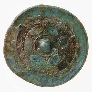 Small domestic imitation mirror (naikō kamonkyō) Middle portion of the Early Kofun period (fourth century, first half). Diameter: 8.0 cm. This was placed among grave goods in Burial 3 of the Motodaka No. 14 tomb. The inner sector of the decorated (back) side has a star-like 6-lobed floral design, the outer sector bears a sawtooth pattern, and a row of pearl-like dots makes a ring between the inner and outer sectors. Because of its small size and the use of 6 arcs in the central design, it is thought to be of Japanese manufacture (an imitation mirror). |
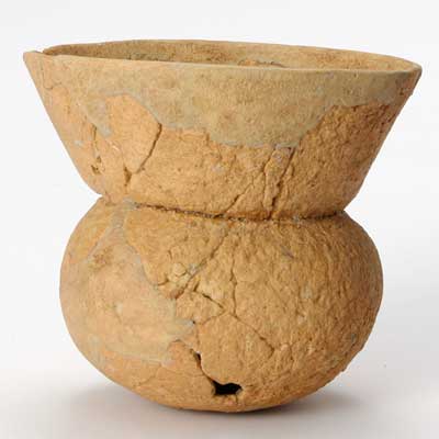 Small round-bottomed jar Middle portion of the Early Kofun period (fourth century, first half). Rim diameter: 9.0 cm; height: 8.0 cm. This was placed on top of the coffin of Burial 5 in the Motodaka No. 14 tomb. From the round hole opened near the base after firing, it is seen to have been a ritual offering. |
Column: The San’in region of the Kofun period as read from mound shapes
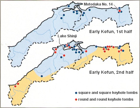
Distribution of tombs in the San’in region
With the exception of Motodaka No. 14 there were only a handful of round keyhole tombs in the first half of the Early Kofun period, but in the second half they are seen to increase gradually. In the vicinity of Lake Shinji, however, square mounds continued to be built.
[Translator’s note: The separate authors of this column and the main text present diverging opinions on the dates of the Motodaka No. 14 tomb, and of the Early Kofun period itself, an area of controversy in current archaeological discourse within Japan.]
In the San’in region, numerous burials in the shape of square mounds with four projecting corners were made during the Late Yayoi period (first to second centuries CE). Entering the Kofun period, perhaps because the influence of this type of mound had been so great, square mounds continued to be constructed here, as opposed to other regions where keyhole tombs were starting to be built. With the exception of Motodaka No. 14, no keyhole tombs were constructed in this region during the first half of the Early Kofun period (the latter half of the third century).
In the latter half of the Early Kofun period (from the first of the fourth to the mid decades of the century), within the San’in region separate changes are seen in the areas of modern Tottori prefecture to the east, and Shimane prefecture to the west.
First, everywhere in the Tottori area, mounds based on circular shapes such as plain round and round keyhole tombs were built one after another. In contrast, in the Shimane area nearly all tombs continued to be based on square shapes, and even though some round tombs were built, their numbers were not great until round keyhole tombs finally made their appearance at the end of the Early Kofun period.
Whether or not tombs have common mound shapes is thought to indicate political ties among the chiefs buried in them. The situation in the San’in region of not building keyhole tombs as the curtain rose on the Kofun period is probably the result of maintaining its individuality from the start of the Yayoi period on. But the manner in which keyhole tombs gradually came to be built from the Tottori area tells how the central authority of the day extended its influence from Kinai into the San’in region. The person buried in Motodaka No. 14 was probably the first chief to enter into relations with the central Kinai authority. (Hayashi Masanori)
