
Fukuchiyama City, Kyoto Prefecture
First half, Upper Paleolithic period (approximately 36,000 years ago)
Circular settlement These features are named from the circular formation of stone tool blocks. The center is plaza-like and has almost no stone tools. Various theories hold that these sites served as places for making and exchanging stone tools, for holding festivals, for seeking intergroup detente and conciliation, and so forth.
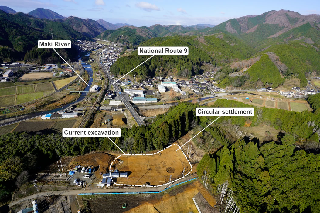
Distant view of the site (from the east) The site spreads over a low tableland offering an overview of the mountain belts and rivers flowing through valley channels of the Tanba region far into the distance. While not as severe as during the Late Glacial Maximum of the Last Glacial Period (approximately 25,000 years ago), the climate at the time was colder than at present, and coniferous trees are thought to have been widespread. Adapted from Hakkutsu sareta Nihon rettō 2022 [Excavations in the Japanese Archipelago, 2022] (Bunkachō [Agency for Cultural Affairs], ed., Kyodo News, 2022).
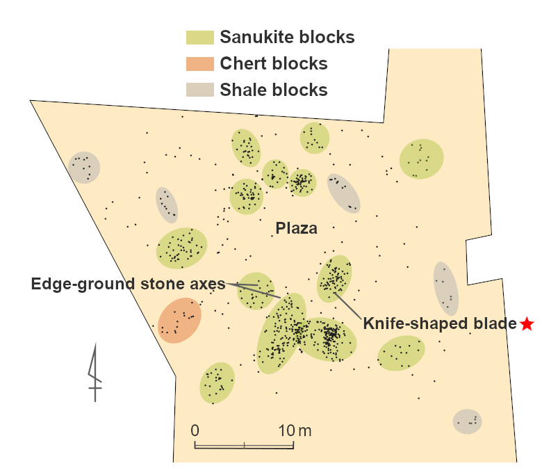
Plan of the entire circular settlement Nineteen stone blocks were distributed encircling a plaza. The stone blocks are regarded as loci of stone tool making, and three or four blocks are held by some as forming a household unit. In that case, this can be thought of as the settlement or campground of about 20 to 30 people. Adapted from Hakkutsu sareta Nihon rettō 2022 [Excavations in the Japanese Archipelago, 2022] (Bunkachō [Agency for Cultural Affairs], ed., Kyodo News, 2022).
Adapted from Hakkutsu sareta Nihon rettō 2022 [Excavations in the Japanese Archipelago, 2022] (Bunkachō [Agency for Cultural Affairs], ed., Kyodo News, 2022).
Adapted from Hakkutsu sareta Nihon rettō 2022 [Excavations in the Japanese Archipelago, 2022] (Bunkachō [Agency for Cultural Affairs], ed., Kyodo News, 2022).
Paleolithic people living in the Tanba Highland: The first “circular settlement” in Kyoto Prefecture
Stone tools recovered from shortly after the arrival of modern humans
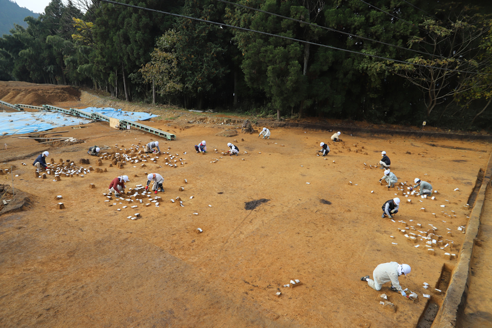
The Chigono site lies in the Tanba Highland in the northwestern portion of Kyoto Prefecture, located atop a low tableland formed by the confluence of two rivers. It was previously known as a site extending from the Jōmon to the Heian periods, but as the result of conducting an excavation in conjunction with construction to improve national Route 9, approximately 1,500 stone tools made by people of the Paleolithic period of around 36,000 years ago were discovered. This date was induced from the stone tool assemblage being recovered from strata in between the Aira volcanic ash layer of about 30,000 years ago and the Daisen Kurayoshi ash layer of approximately 50,000 years before the present, and from comparisons of the shapes and method of making the stone tools with materials recovered from sites of the same age. This corresponds to the first half of the Upper Paleolithic, shortly after modern humans arrived in the Japanese archipelago. From the distribution of the recovered stone tools, the site was also seen to have been a settlement or campground of people of the time.
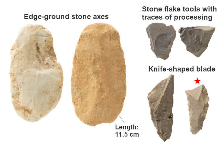
The recovered stone tools divide into those retaining clear traces of processing, and large volumes of debitage produced when these were made. The former include knife-shaped blades used as spearpoints and flake tools with sharp edges used for cutting various things, and edge-ground stone axes. Among these, the edge-ground axes with only the blade tips on one end polished were used according to some theories for butchering hunted prey in addition to felling trees, and are a stone tool symbolizing the first half of the Upper Paleolithic period. Beginning with sanukite, the stone material included chert, obsidian, shale, and so forth. As there are no sources nearby for either sanukite or obsidian, these were brought from distant locales, the sanukite from Mount Nijō on the border between Nara and Osaka Prefectures, and the obsidian from the Oki Islands of Shimane Prefecture. It is thought that the Hikami Corridor, a route permitting movement from the Sea of Japan to the Inland Sea at an elevation not exceeding 100 m, was used for the transport of sanukite.
Exchanges with people from all over in the midst of a cold climate
Looking at the distribution of the stone tools, there were “stone tool blocks” of several meters’ extent discovered at 19 locations where stone tools concentrated. A feature of these stone tool blocks’ distribution is that they enclosed a plaza-like space in the center where stone tools were not recovered. Such ring-shaped groups, called “circular settlements” and appearing only in the first half of the Upper Paleolithic, are spaces where stone tool making accompanied settlement. While these have been found in many sites centering on the Kantō region, this is the second example of a discovery in Kinki, following the Itai Teragadani site in Hyōgo Prefecture.
The climate at the time was colder than at present, and the coastline of the Japanese archipelago had receded far seaward. In this verdant mountainous landscape composed mainly of coniferous trees, we can imagine the figures of Upper Paleolithic people at times hunting big game in groups, and roaming over a vast area as far as Mount Nijō or the Oki Islands to obtain materials for stone tools. Their stone tools show elements in common in the shape and way of manufacture with sites of the Hokuriku and Tōhoku regions, in addition to those of Chūgoku and Kinki. It may be said that this discovery at the Chigono site is a great achievement for understanding the lives and wide-area movements of people of the Upper Paleolithic period in the Tanba Highland. (Kurotsubo Kazuki)