
Shingū City, Wakayama Prefecture
End of the Heian–Muromachi periods (end of the twelfth–first portion of the sixteenth centuries)
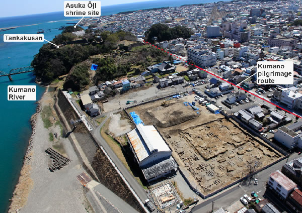
Distant view of the site (from the northwest) As a small hill called Tankakusan juts out to the Kumano River on the site’s eastern side, the topography shields it from the effects of wind and waves and makes it suited as a harbor. Adapted from Hakkutsu sareta Nihon rettō 2022 [Excavations in the Japanese Archipelago, 2022] (Bunkachō [Agency for Cultural Affairs], ed., Kyodo News, 2022).
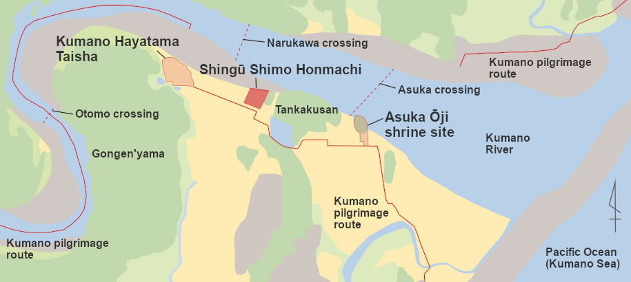
Map of the site’s location The pilgrimage route linking the Kumano Hayatama Taisha shrine and the site of the Asuka Ōji shrine runs immediately to the site’s south. It is just 0.5 km to the Kumano Hayatama Taisha shrine. Adapted from Hakkutsu sareta Nihon rettō 2022 [Excavations in the Japanese Archipelago, 2022] (Bunkachō [Agency for Cultural Affairs], ed., Kyodo News, 2022).

Plan of the entire site (boxed numbers correspond to the separate photos) Adapted from Hakkutsu sareta Nihon rettō 2022 [Excavations in the Japanese Archipelago, 2022] (Bunkachō [Agency for Cultural Affairs], ed., Kyodo News, 2022).
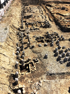
1 Group of warehouses (from the west) These are lined up along a stepped terrace facing the Kumano River. The round columns are foundation pillars of an elementary school standing at the site prior to the investigation.
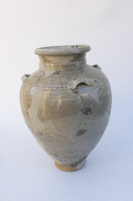
9 White porcelain jar with four handles Of Chinese manufacture with the characters 李丁 incised on a handle. Height: 32 cm. Kamakura period.
A Medieval maritime transport base that supported the Kumano cult
Subterranean warehouses in a variety of structures lined up by the Kumano River
The Shingū Shimo Honmachi site is located atop a natural levee on the southern bank of the Kumano river, approximately 2 km upstream from the river mouth. Shingū is a strategic point for maritime traffic going back and forth over the Pacific Ocean, and as the Kumano Hayatama Taisha shrine, one of the three Kumano Sanzan Shinto shrines that are the focus of the Kumano cult, is located nearby, Shingū developed as the town built around the shrine. The city of Shingū has conducted excavations at this site multiple times starting in the 2015 fiscal year, ascertaining artifacts and features from the Jōmon to the Early Modern periods. Among these, features related to the Medieval harbor have drawn attention. While no boat landing has been discovered, from the location adjacent to the Kumano River and the discovery of a group of warehouses, the site is regarded as part of a Medieval port town.
As features that have been confirmed, there are embedded-pillar buildings, square pit-structures, stone step pathways, stone walls, and blacksmithing features. Among these, there were more than 30 square pit-structures found, with their purpose thought to be as subterranean warehouses, characterizing the port town. They are all on a scale of 2–3 m square, with a variety of structures including embedded pillars, earthen foundations, and stonework. These differences in structure indicate among other things the different periods of the start of their construction, and in the fifteenth century there were three types built in parallel.
To the north of the site, near the Kumano River, prior to the fifteenth century the slope leading down to the river was not outfitted in any way, but in the fifteenth century when the greatest number of warehouses were built, stepped terraces were prepared and stone walls erected on the slope. From the construction as well of stone step pathways leading down to the river, etc., it appears that development of the town was carried out in planned fashion. Also, blacksmithing features concentrate at the stepped terraces of the northeast portion of the site, and as boat nails were also recovered, it is thought that ship repair work and so forth was conducted. These features and their layout bring to mind of the form of a Medieval port town developed in planned fashion.
Numerous artifacts telling of exchanges with various places east and west
The recovered artifacts are diverse, including imported glazed wares and porcelains, Tokoname ware, Seto ware, Bizen ware, Haji ware cooking pots (southern Ise style, Harima type), Yamajawan, and Ga ware, indicating active exchange with various places to the east and west, centering on the Kii Peninsula. Also, as Seto ware candlesticks and flower vases, sets of brass utensils used for offerings (esoteric Buddhist paraphernalia), and other religiously related items were recovered, close relations can be glimpsed with religious institutions starting with Kumano Hayatama Taisha. In the Medieval period the Kumano cult prospered, and manors belonging to Kumano shrines spread throughout the country. Water transport developed as a means of conveying the rice harvests from these manors in various regions, supporting the finances of the three Kumano Sanzan shrines. The port-related features verified at this site indicate the actual conditions of this flow of goods.
In this manner, along with allowing us to know the structure of a Medieval port town, Shingū Shimo Honmachi is a precious site for bringing to light the actual state of Pacific Ocean traffic of the Medieval period, against the background of the rise in prosperity of religious forces. (Kobayashi Kōta)